Let’s analyze the name Chapainawabganj. It’s made up of three words “chapai”, ” nawab” and “ganj”. Ganj originally meant “treasure” in Middle Persian and Modern Persian. In the Indian subcontinent it is a common suffix attached after a place name to mean a “treasured place” or “neighbourhood” especially in Hindi, Bengali and Urdu. It is used in the names of bazaar, mandi, store, market place and towns in India, Bangladesh and Nepal.
We don’t need to explain the word Nawab. It came to existence during the Nawabi rule of Bengal.
Now let’s analyze Chapai or chapain.
In 1947, during the partition, the place was severed from the Indian district of Malda and given to East Pakistan as a sub-division of Rajshahi district. It became a separate district of Bangladesh in 1984. The north and west part of Chapai Nawabganj is bounded by Malda and Murshidabad district of India, east is by Naogaon District, and south-east is by Rajshahi District.
The name “Chapainawabganj” does not appear between the time Alivardi Khan to 2000-2001. During that time it was known as Nawabganj or Nobabganj. In the pre-British or British-raj era, this place was a vacation spot for the nawabs of Murshidabad and Daudpur Mouja was the particular place of their vacation. Thus why the place was known as “Nobabganj”. Most researchers believe that during the reign of Alivardi Khan (1740–56 AD), this place was given the name Nobabganj or Nawabganj.
However, before it became known as Nawabganj, it was a part and surrounding area of a village named “Chapai”.
According to one account, during the start and middle of the 18th century, people migrated from Kolkata to Nawabganj to a great degree. There was a post office at that time which was located in Chapai village. This migration led to the enlargement of the village. The place was known widely as Chapai Nawabganj.
A popular belief among the Hindus about the name of this place is that the king Lakhindar (son of Chand Sadagar/husband of Behula Vasan) lived here and his capital’s name was “Champok” or Champak. There is still a place named “Chosai”, and “Behula”. There is also a river named Behula River. The river currently flows through Malda. According to historian Aksai Kumar Moitrio (1861–1930 CE), Behula crossed the river Mahananda with her husband using a boat made of a tree. Dr. Muhammad Shahidulla (1885–1969 CE) cited in his book “Bangla Sahitter Kotha” that the enemy of laoson entered into Gaur through “Jamutinagar”. “Jamuti Nagar” still exists in this area. Based on these beliefs, researchers believe that the home of Bahula’s father-in-law was in “Champok Nagar” and with time the local dialect turned Champok or Champak in to Chapai and then the final product was Chapai Nawabganj.
Administrative history
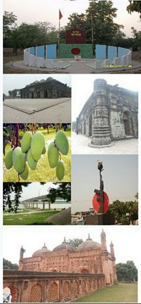
Chapainawabganj was one of the sub-divisions of the former Rajshahi zilla. Chapai Nawabganj was part of ancient Gour capital. It is said that this area had strategic and commercial importance due to its location at the junction of the rivers Mahananda and the Ganges. Because of its importance, Alivardi Khan founded Nowabganj town which in course of time known as Nawabganj. Until 1947, Nawabganj was a thana under Malda district, India.
The gateway of North Bengal, Malda was once the capital of Gour-Banga, with 3456 km2 of land classified as Tal, Diara, and Barind. Malda awaits the advent of tourists and people of archaeological interest with its wealth to be enjoyed and its huge potential to be explored.
This portion of the earth is washed by the waves of the rivers Ganges, Mahananda, Fulahar, and Kalindri. It has witnessed different empires which were raised, flourished, and then cast down near oblivion by a successor kingdom built up on the relics of its predecessor. Panini mentioned a city named Gourpura, which by strong reason may be identified as the city of Gouda, ruins of which are situated in this district. Examples are legion of the relic of a predecessor kingdom being used in the monuments of the successor kingdoms. It had been within the limits of ancient ‘Gaur’ and ‘Pandua’ (Pundrabardhana).
These two cities had been the capital of Bengal in ancient and medieval ages. The boundary of Gour was changed in different ages since 5th century BC. Its name can be found in Puranic texts. Pundranagar was the provincial capital of Maurya Empire. Gour and Pundrabardhana formed parts of the Mourya empire as is evinced from the inscriptions, Brahmilipi on a seal discovered from the ruins of Mahasthangarh in the Bogra District of Bangladesh. Hiuen Tsang saw many Ashokan stupas at Pundrabardhana. The inscriptions discovered in the district of undivided Dinajpur and other parts of North Bengal along with the Allahabad Pillar inscriptions of Samudragupta clearly indicate that the whole of North Bengal as far east as Kamrup formed a part of the Gupta empire.
After the Guptas in the early 7th century AD, king Sasanka of Karnasubarna as well as the king of Gaur ruled independently for more than three decades. From the middle of 8th century to the end of 11th century, the Pala Empire ruled Bengal and the kings were devoted to Buddhism. It was during their reign that the Jagadalla Vihara (monastery) in Barindri flourished paralleling with Nalanda, Vikramshila, and Devikot. The Pala Dynasty yielded to the emergence of Sena Empire. The Sen rulers were Hindus and in the habit of moving from place to place within their kingdom. At the time of Lakshman Sen Gour was known as Lakshmanabati. The Sen kings ruled Bengal till Bakhtiyar Khilji conquered Bengal in 1204 AD. Thereafter the Muslim rule lasted for about five hundred years. Sirajuddaulah was defeated by Lord Clive at the battle of Plassey in 1757, which marked the beginning of British rule. From ancient times, rulers of various origins, religions, and dynasties left imprints of their times on the earth in this district. Those who left ruins and relics speak of past pomp and grandeur, and hold interest for archaeologists and tourists.
This district, Malda, formed in 1813 out of the outlying areas of Purnia, Dinajpur, and Rajshahi districts. At the time of Dr. B. Hamilton (1808–09), the presents thanas of Gazole, Malda, Bamongola, and part of Habibpur were included in the district of Dinajpur and the thanas of Harischandrapur, Kharba, Ratua, Manikchak, and Kaliachak were included in the district of Purnia. In 1813, in consequence of the prevalence of serious crimes in the Kaliachak and Sahebganj thanas and also on the rivers, a joint magistrate and deputy collector were appointed at English Bazar with jurisdiction over a number of police stations centred around that place and taken from the two district. Thus the district of Malda was born.
The year 1832, saw the establishment of a separate treasury, and in 1859 a full-fledged magistrate and collector was posted. Up to 1876 this district formed part of Rajshahi Division, and from 1876 to 1905 it formed part of Bhagalpur Division. In 1905, it was again transferred to Rajshahi Division, and until 1947 Malda remained in this division. In August 1947 this district was affected by the Partition of India. Between 12 and 15 August 1947 whether the district would become part of India or Pakistan was unknown, as the announcement of the Radcliffe Line did not make this point clear. During these few days the district was under a magistrate of East Pakistan until the details of the Radcliffe award were published and the district became part of West Bengal on 17 August 1947. Five thanas were given to Pakistan under the district of Rajshahi which later formed as Chapai Nawabganj.